


Tập tin:RomanEmpire 117.svg

Tập tin gốc (tập tin SVG, 512×376 điểm ảnh trên danh nghĩa, kích thước: 704 kB)

Miêu tả
| Miêu tả |
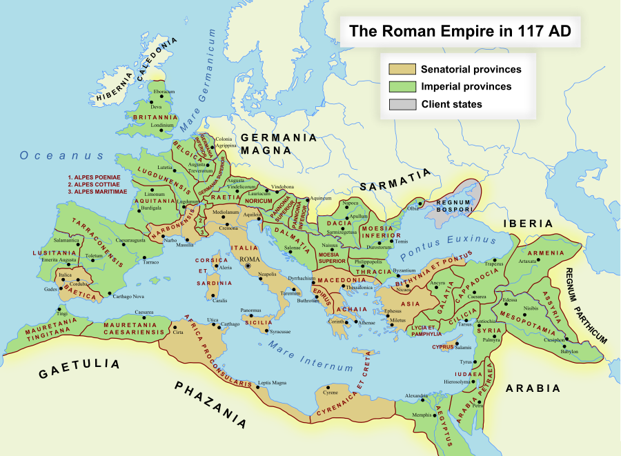
English: The maximum extent of the Roman Empire. Superimposed on a physical map. Senatorial Provinces Imperial Provinces Client States Español: Máxima extensión del Imperio Romano. Superpuesto en un mapa físico. Provincias Senatoriales Provincias Imperiales Estados satélite Deutsch: Das Römische Reich zur Zeit seiner maximalen Ausdehnung unter Trajan, 117 n. Chr. Senatorische Provinz Kaiserliche Provinz Klientelkönigtum Latina: Extentum maximum de Imperium Romanum. Provinciae senatus Provinciae Imperii Civitates Clientes 中文:公元117年图拉真在位时期罗马帝国的最大疆域。 元老院行省 元首行省 附庸国 日本語: ローマ帝国の最大版図。(西暦117年、皇帝トラヤヌス) 元老院属州 皇帝属州 従属国 |
| Ngày | 17 tháng 10 năm 2005 (first version); 19 tháng 12 năm 2007 (last version) |
| Nguồn gốc | Chuyển từ en.wikipedia sang Commons. |
| Tác giả | ArdadN tại Wikipedia Tiếng Anh |
| Giấy phép (Dùng lại tập tin) |
Public Domain |
| Phiên bản khác |
[]
|
| SVG genesis |


SVG Support
This document is in the Scalable Vector Graphic format (SVG) and requires a supported browser (Firefox, Google Chrome, Opera) or a SVG plugin for Internet Explorer and other browsers. SVG is an open, text-based format, which means this map can be downloaded and modified/translated completely using a vector graphics editor like Adobe Illustrator or Inkscape (free) or a text editor such as Notepad.
| BLANK THUMBNAIL | View large PNG | View medium PNG | SVG Plugin for Internet Explorer and other browsers |
|---|---|---|---|
| Click here (purge cache) and then CTRL+F5 to reload. Help? | Try 1 Try 2 | Try 1 Try 2 | Adobe SVG plugin |
| Recommended browser | More Help | ||
| Firefox | List of SVG tools |



Giấy phép
ArdadN tại Wikipedia Tiếng Anh, người giữ bản quyền tác phẩm này, từ đây phát hành nó theo giấy phép sau:

|
Tác phẩm này đã được tác giả của nó, ArdadN tại Wikipedia Tiếng Anh, phát hành vào phạm vi công cộng. Điều này có hiệu lực trên toàn thế giới. Tại một quốc gia mà luật pháp không cho phép điều này, thì: ArdadN tại Wikipedia Tiếng Anh cho phép tất cả mọi người được quyền sử dụng tác phẩm này với bất cứ mục đích nào, không kèm theo bất kỳ điều kiện nào, trừ phi luật pháp yêu cầu những điều kiện đó. |
Lịch sử tập tin
Nhấn vào ngày/giờ để xem nội dung tập tin tại thời điểm đó.
| Ngày/Giờ | Hình xem trước | Kích cỡ | Thành viên | Miêu tả | |
|---|---|---|---|---|---|
| hiện tại | 18:48, ngày 24 tháng 11 năm 2022 | | 512×376 (704 kB) | wikimediacommons>Vikarna | alpes poeniae → alpes poeninae |
Trang sử dụng tập tin
Có 1 trang tại Wikipedia tiếng Việt có liên kết đến tập tin (không hiển thị trang ở các dự án khác):
